ESA's Earth Explorers have again shown how they are surpassing expectations. Designed to map soil moisture and ocean salinity, the versatile SMOS satellite has demonstrated that it can also offer unique information to improve hurricane forecasts.
The Soil Moisture and Ocean Salinity (SMOS) satellite carries a novel microwave radiometer to capture images of .brightness temperature.. These images correspond to radiation emitted from the surface of Earth and can be used to work out how much water is held in soil and how much salt is in the surface waters of the oceans.
This information is leading to a better understanding of the water cycle and the processes that link Earth.s surface and atmosphere.
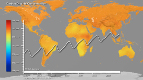
The SMOS sensor works in the .L-band., at frequencies around 1.4 GHz, which also allows surface wind speeds over oceans to be derived, even in cloudy and rainy conditions.
When winds reach gale force over oceans, breaking waves and whitecaps affect the microwave radiation being emitted from the surface. This means that when a storm builds, changes in the emitted radiation can be linked directly to the strength of the wind over the sea.
In addition, the radiation detected by SMOS is far less disturbed by rain and atmospheric effects than higher microwave frequencies.
Since clouds and rain are typical of tropical cyclones, measurements from SMOS uniquely complement observations made in extreme conditions, when measurements from other satellites become less accurate.
This means that SMOS has the potential to improve accuracy for forecasting the strength of tropical cyclones
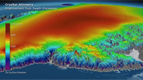
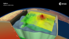
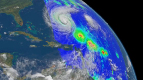
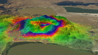
SMOS.s new-found capability was demonstrated by analysing SMOS data over Hurricane Igor, which reached category 5 in the North Atlantic in 2010.
Animation by Planetary Visions
SMOS WATER MISSION TURNS HURRICANE HUNTER
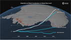
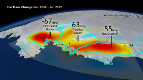
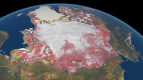
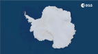
Anctartica hikes up sea-level
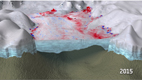
Secrets of Hidden Ice...
Cryosat spacecraft's ice...
Carbon Flux
Searching for underground...
Goce reveals gravity dip from...
Goce: The first seismometer...
Clearest evidence yet of polar...
SMOS water mission turns...
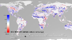
Over 30 years of global soil...
Mapping the MOHO with GOCE
SMOS versatility offers sea ice...
Carbon gases
Africa's ups and downs
Arctic lakes show climate on...
Pine Island retreat on the radar