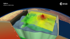
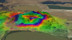
Animation of geological activity of the East African Rift as observed by radars on the Envisat and ALOS satellites. This animation is based on a study by Juliet Biggs from the University of Bristol, UK, as part of ESA.s STSE Changing Earth Science Network Initiative
The East African Rift is an area where two tectonic plates are moving apart, making it a region of high geological activity, home to a number of volcanoes
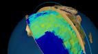
This animation shows how satellite radars . like the one flown on Envisat . can detect surface displacement with centimetre accuracy from an altitude of about 800 km.
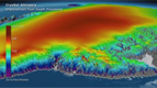
Interferometric Synthetic Aperture Radar . or InSAR . is a remote sensing technique where two or more radar images over the same area are combined to detect slight surface changes between them.
Tiny changes on the ground cause changes in the radar signal and lead to rainbow-coloured interference patterns in the combined image, known as a .SAR interferogram.. These interferograms can then show how land is uplifting or subsiding.
For example, Envisat found that the dormant Mount Longonot in Kenya rose by 9 cm from 2004 to 2006. Tectonic activity such as the movement of magma underground may have caused this deformation of the surface above.
Radars can also identify fault lines . such as the radar on the Japanese ALOS satellite. Ground displacement following a series of earthquakes around Karonga, Malawi, was detected in the interferogram, revealing details of a fault line. The visualisations are based on results by Juliet Biggs from the University of Bristol in the UK.
Measurements like those seen in this animation are helping scientists to understand plate tectonics. They provide insights into patterns and consequences of activity that can help to get a clearer picture of a volcano.s behaviour.
Animation by Planetary Visions
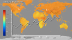
AFRICA'S UPS AND DOWNS
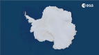
Anctartica hikes up sea-level
Secrets of Hidden Ice...
Cryosat spacecraft's ice...
Carbon Flux
Searching for underground...
Goce reveals gravity dip from...
Goce: The first seismometer...
Clearest evidence yet of polar...
SMOS water mission turns...
Over 30 years of global soil...
Mapping the MOHO with GOCE
SMOS versatility offers sea ice...
Carbon gases
Africa's ups and downs
Arctic lakes show climate on...
Pine Island retreat on the radar