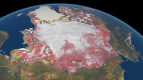
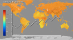
After two decades of satellite observations, an international team of experts brought together by ESA and NASA has produced the most accurate assessment of ice losses from Antarctica and Greenland to date. This study finds that the combined rate of ice sheet melting is increasing.
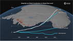
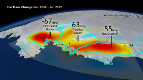
The new research shows that melting of the Antarctic and Greenland ice sheets has added 11.1 mm to global sea levels since 1992. This amounts to about 20% of all sea-level rise over the survey period.
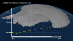
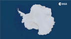
About two thirds of the ice loss was from Greenland, and the remainder was from Antarctica.
Although the ice sheet losses fall within the range reported by the Intergovernmental Panel on Climate Change in 2007, the spread of the estimate at that time was so broad that it was not clear whether Antarctica was growing or shrinking.
The new estimates are a vast improvement . more than twice as accurate . thanks to the inclusion of more satellite data, and confirm that both Antarctica and Greenland are losing ice.
The study also shows that the combined rate of ice sheet melting has increased over time and, altogether, Greenland and Antarctica are now losing more than three times as much ice, equivalent to 0.95 mm of sea-level rise per year, as they were in the 1990s, equivalent to 0.27 mm of sea level rise per year.
The 47 experts combined observations from 10 different satellite missions to reconcile the differences between dozens of earlier ice sheet studies and produce the first consistent measurement of polar ice sheet changes.
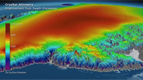
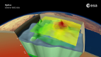
Earth observation satellites are key to monitoring the polar ice because they carry instruments that measure changes in the thickness of the ice sheets, fluctuations in the speed of the outlet glaciers and even small changes in Earth.s gravity field caused by melting ice.
As outlined in the paper .A Reconciled Estimate of Ice Sheet Mass Balance. published today in Science, the researchers carefully matched time periods and survey areas, and combined measurements from European, Canadian, American and Japanese satellites.
The measurement were acquired by instruments such as the radar altimeters and synthetic aperture radars flown on ESA.s ERS-1, ERS-2 and Envisat missions from 1991.
The success of this venture is due to the cooperation of the international scientific community, and to the provision of precise satellite sensors by our space agencies,. said Professor Andrew Shepherd from the University of Leeds and one of the leaders of the study.
Without these efforts, we would not be in a position to tell people with confidence how Earth.s ice sheets have changed, and to end the uncertainty that has existed for many years.
Animation by Planetary Visions
CLEAREST EVIDENCE YET OF POLAR ICE LOSSES
Anctartica hikes up sea-level
Secrets of Hidden Ice...
Cryosat spacecraft's ice...
Carbon Flux
Searching for underground...
Goce reveals gravity dip from...
Goce: The first seismometer...
Clearest evidence yet of polar...
SMOS water mission turns...
Over 30 years of global soil...
Mapping the MOHO with GOCE
SMOS versatility offers sea ice...
Carbon gases
Africa's ups and downs
Arctic lakes show climate on...
Pine Island retreat on the radar