ESA's SMOS mission is proving to be extremely versatile. Not only does this pioneering satellite offer crucial data on soil moisture and ocean salinity, but it can also map the thickness of ice floating in the polar seas.
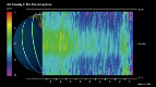
The Soil Moisture and Ocean Salinity (SMOS) satellite carries an innovative passive microwave radiometer to capture images of .brightness temperature.. These images correspond to microwave radiation emitted from Earth.s surface and can be related to soil moisture and ocean salinity.
This information is essential for improving our understanding of the exchange processes between the atmosphere, land and oceans . Earth.s water cycle.
Although not a primary objective, it was suggested that the radiometer, which uses a wavelength of 21 cm (L-band), would also be able to detect sea ice, which is another important component of the water cycle.
In fact, an experiment campaign in 2007 over the Baltic Sea using an airborne version of the SMOS instrument confirmed that the mission had the potential to measure thin sea ice.
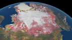
A group of scientists led by Prof. Kaleschke from the University of Hamburg's Institute of Oceanography has now developed and refined a method to make this a reality . showing, indeed, that SMOS data can be used to map sea ice routinely.
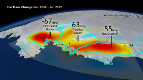
Moreover, the team has gone one step further so that the thickness of the sea ice can also be inferred. The information from SMOS is most reliable for ice that is thinner than 1 m.
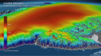
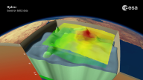
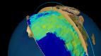
As an example, the animation above shows how the sea ice in the Laptev Sea, which lies off northern Russia in the Arctic Ocean, advanced and thickened between 10 November and 10 December this year.
Animation by Planetary Visions
SMOS VERSATILITY OFFERS SEA ICE MAPPING
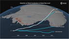
Anctartica hikes up sea-level
Secrets of Hidden Ice...
Cryosat spacecraft's ice...
Carbon Flux
Searching for underground...
Goce reveals gravity dip from...
Goce: The first seismometer...
Clearest evidence yet of polar...
SMOS water mission turns...
Over 30 years of global soil...
Mapping the MOHO with GOCE
SMOS versatility offers sea ice...
Carbon gases
Africa's ups and downs
Arctic lakes show climate on...
Pine Island retreat on the radar